BACK to All County Map Olympic Peninsula

Jefferson County

Olympic Peninsula roads, ferry approaches, forest routes, and coastal travel conditions.

WSDOT live data

Travel Conditions

4 stations / 4 cameras / 3 passes

Road Weather Stations

4 nearby
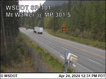
Mt Walker US 101 at mp 301.54 0.6 mi away · Updated Jul 27, 12:45 AM
AirNot reported Wind0 mph / gust 0 mph N RainNot reported Visibility1 mi

N/A

Diamond Point on US 101 at mp 274.60 21.0 mi away · Updated Jul 27, 12:45 AM
Air55 F Wind0 mph / gust 0 mph N RainNot reported Visibility1 mi

N/A · Humidity 100%

Seibert Creek Bridge on US 101 at mp 256 29.7 mi away · Updated Jul 27, 12:45 AM
Air55 F Wind0 mph / gust 0 mph N RainNot reported Visibility0 mi

N/A · Humidity 97%

Indian Valley on US 101 at mp 237.17 40.4 mi away · Updated Jul 27, 12:45 AM
Air58 F Wind0 mph / gust 0 mph N RainNot reported Visibility1 mi

N/A · Humidity 96%

WSDOT Cameras

4 cameras

Pass Conditions

3 passes
North Cascade Hwy SR 20 SR 20 North Cascade Highway is open as of Sunday, June 14. Traditionally, weather and road conditions are reported from November 1 to April 1. Should adverse weather occur that will impact travel, updates will be provided as information is available.
WSDOT · Updated Jun 14, 1:19 PM
Loup Loup Pass SR 20 Reports have ended for this season. Traditionally weather and road conditions are reported on this page from November 1 to April 1. Should adverse weather occur that will impact travel, updates will be provided as information is available.
60°F · Updated Apr 24, 6:54 AM
Wauconda Pass SR 20 Reports have ended for this season. Traditionally weather and road conditions are reported on this page from November 1 to April 1. Should adverse weather occur that will impact travel, updates will be provided as information is available.
56°F · Updated Apr 24, 6:54 AM
Road conditions

Road Alerts

7 active
Construction High priority Source: WSDOT Highway Alerts

Construction

536: WSDOT alert for Jefferson County.

The SR 536 Skagit River Bridge is closed to eastbound traffic until early 2027 to repaint the bridge. Eastbound vehicles should detour using eastbound SR 20 and southbound I-5.

The bridge remains open to westbound traffic. Pedestrians bicycles and emergency vehicles may use the bridge in both directions.

More information on project webpage
View source on WSDOT
Road alert Medium priority Source: WSDOT Highway Alerts

Maintenance

101: WSDOT alert for Jefferson County.

Reduced speeds and one-way alternating traffic controlled by a signal is in place until further notice on US 101 near Cedar Creek at milepost 165.
View source on WSDOT
Construction Low priority Source: WSDOT Highway Alerts

Construction

101: WSDOT alert for Jefferson County.

Expect around-the-clock single-lane alternating traffic on US 101 at the Jefferson-Clallam county line. The speed limit is reduced to 25 mph between mileposts 184 and 185. Crews are building a bridge to improve fish passage in May Creek.
View source on WSDOT
Construction Low priority Source: WSDOT Highway Alerts

Construction

101: WSDOT alert for Jefferson County.

Expect temporary traffic lights and single-lane alternating traffic around the clock on US 101 near Ruby Beach. The speed limit is reduced from 55 mph to 25 mph from milepost 162.93 to 163.51. Work is for a fish passage project.
View source on WSDOT
Construction Low priority Source: WSDOT Highway Alerts

Construction

101: WSDOT alert for Jefferson County.

Expect daytime mobile paving operations on US 101 between Queets and Lake Quinault from 6 a.m. to 6 p.m. Monday through Friday. Pilot cars will alternate directions of traffic as paving crews work in northbound and southbound directions. More information on the project webpage.
View source on WSDOT
Construction Low priority Source: WSDOT Highway Alerts

Construction

101: WSDOT alert for Jefferson County.

Expect around-the-clock single-lane alternating traffic approaching milepost 184 near Dowans Creek Road. The road is reduced to one lane until permanent repairs are completed due to a slide.
View source on WSDOT
Construction Low priority Source: WSDOT Highway Alerts

Construction

101: WSDOT alert for Jefferson County.

Until further notice travelers can expect one-way alternating traffic controlled by a temporary signal and a reduced speed of 25 mph at the US 101 Hoh River Bridge (milepost 176) south of Forks for emergency repairs.
View source on WSDOT
Weather alerts

Weather Alerts / Red Flag Warnings

0 active

No active weather alerts

No active weather alerts or Red Flag warnings have been posted for this county.

Public health

Health Dept Alerts

1 active
Health Dept alert High priority Source: WA DOH Shellfish Safety Map

Shellfish harvest closure - Jefferson County

WA DOH lists 50 current recreational shellfish closures in Jefferson County. Check the Shellfish Safety Map before harvesting.

WA DOH Shellfish Safety Map currently lists the following closed recreational harvest area(s):
- BOLTON PENINSULA: All Species (Water quality and shoreline conditions meet public health standards for recreational shellfish harvesting.)
- CASE SHOAL: All Species (Water quality and shoreline conditions meet public health standards for recreational shellfish harvesting.)
- CHIMACUM CREEK TIDELANDS: All Species (Water quality and shoreline conditions meet public health standards for recreational shellfish harvesting.)
- DABOB BROADSPIT: All Species (Water quality and shoreline conditions meet public health standards for recreational shellfish harvesting.)
- DNR 404A (KINNEY POINT): All Species (Water quality and shoreline conditions meet public health standards for recreational shellfish harvesting.)
- DNR 57: All Species (Water quality and shoreline conditions meet public health standards for recreational shellfish harvesting.)
- DNR 57-B: All Species (Water quality and shoreline conditions meet public health standards for recreational shellfish harvesting.)
- DNR-409: All Species (Water quality and shoreline conditions meet public health standards for recreational shellfish harvesting.)
- DNR-59: All Species (Water quality and shoreline conditions meet public health standards for recreational shellfish harvesting.)
- DOSEWALLIPS SP: All Species (Water quality and shoreline conditions meet public health standards for recreational shellfish harvesting.)
- DOSEWALLIPS SP SOUTH: All Species (Water quality for this beach does not meet Washington State standards for recreational shellfish harvesting.)
- DUCKABUSH: All Species (Water quality for this beach does not meet public health standards for recreational shellfish harvesting for portions of the year.)
- E DABOB: All Species (Water quality and shoreline conditions meet public health standards for recreational shellfish harvesting.)
- FORT FLAGLER SP: All Species (Water quality and shoreline conditions meet public health standards for recreational shellfish harvesting.)
- FORT WORDEN SP: All Species (This beach is partially within a PROHIBITED commercial shellfish area. The area inside the PROHIBITED zone is classified CLOSED. The area outside the PROHIBITED zone is UNCLASSIFIED due to lack of data at this time to classify it.)
- INDIAN ISLAND CP/ISTHMUS BEACH: All Species (Water quality and shoreline conditions meet public health standards for recreational shellfish harvesting.)
- INDIAN ISLAND CP/LAGOON BEACH: All Species (Water quality and shoreline conditions meet public health standards for recreational shellfish harvesting.)
- KALALOCH: All Species (Water quality and shoreline conditions meet public health standards for recreational shellfish harvesting.)
- MYSTERY BAY SP: All Species (This beach is near a seasonally used marina. Shellfish should not be harvested during periods of high boat usage as indicated below.)
- N MCDANIEL COVE: All Species (Water quality and shoreline conditions meet public health standards for recreational shellfish harvesting.)
- N TABOOK PT: All Species (Water quality and shoreline conditions meet public health standards for recreational shellfish harvesting.)
- NORTH BEACH CP: All Species (This beach is within the closure area for a sewage treatment plant outfall and is unsafe for recreational shellfish harvesting.)
- NORTH POINT HUDSON: All Species (Water quality and shoreline conditions meet public health standards for recreational shellfish harvesting.)
- OAK BAY CP: All Species (Water quality and shoreline conditions meet public health standards for recreational shellfish harvesting.)
- OLD FORT TOWNSEND SP: All Species (This beach has not been evaluated by the Department of Health for pollution problems. Contact your local health department for local information about pollution problems in this area.)
- PLEASANT HARBOR STATE PARK: All Species (This beach lies within a marina closure zone. It is classified CLOSED for recreational shellfish harvesting.)
- PLEASANT HARBOR WDFW BOAT RAMP: All Species (This beach lies within a marina closure zone. It is classified CLOSED for recreational shellfish harvesting.)
- POINT HANON: All Species (Water quality and shoreline conditions meet public health standards for recreational shellfish harvesting.)
- PORT TOWNSEND SHIP CANAL/PORTAGE BEACH: All Species (Water quality and shoreline conditions meet public health standards for recreational shellfish harvesting.)
- PT WHITNEY LAGOON: All Species (Water quality and shoreline conditions meet public health standards for recreational shellfish harvesting.)
- Plus 20 more closure row(s) on the WA DOH map.
Cooking or freezing does not remove marine biotoxins. WA DOH shellfish safety hotline: 1-800-562-5632.
View source on WA DOH Shellfish Safety Map
Fire & public safety

Fire & Safety Alerts

0 posted

No fire or safety alerts

No fire or public safety alerts have been posted for this county.

Wildlife safety

Wildlife Safety Alerts

0 posted

No wildlife safety alerts

No official cougar, bear, wolf, or other dangerous wildlife alerts have been posted for Jefferson County.

For an immediate threat, call 911. For non-emergency dangerous wildlife reports, call WDFW at 877-933-9847.

View WDFW wildlife incident reports WDFW dangerous wildlife guidance
Local links

Resources

58 links